Thursday, December 29, 2011
Little Peak 3440' 600'P 12.29.11
For once I had a plan for this day however the weather had other plans for me. I wanted to stay on the West side of the crest but when I made my way up I-90 the rain was torrential and making it worse it was quite warm. Not enthused with spending a day getting drenched I kept driving without a destination in mind. I hoped the weather would be better East of the crest. As I made my way towards Easton the skies showed no sign of letting up. As I neared the Nelson Siding Road I felt an urge to turn off so I did. As I made my way down Nelson Siding I remembered a couple of previous trips in the area. I used the Granite Creek Trailhead but I remember that the road continues with two other trailheads further along. This seemed like a good day to do some exploring. The road turns into a groomed snowmobile road so I had to turn around and park. The rain was still pounding as I suited up.
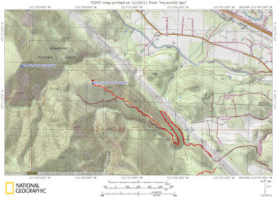
Thankfully I had enough gear to stay dry and shortly after leaving the car the rain magically stopped. I walked the road which seemed to lose more elevation than it gained. The road was well packed making for easy travel. I reached a junction and chose the one heading up hill. After another mile I reached a saddle and took the branch heading SW. I didn't have a map so I wasn't sure but it seemed the road was heading to a distinct point giving the day a worthy goal. I was able to see a snowshoe trench heading towards the ridge crest so I followed. I was happy to see that there was some foot traffic making me feel a little less crazy. At least I wasn't alone in my pursuit of some unnamed high point. The ridge is long set off small bumps which would be much easier to bypass by staying on the road. Since I didn't know this I thought each bump would be the summit. Since I thought each bump was the summit I resisted putting on the snowshoes. Becoming frustrated of this up and down regimen I rejoined the road until the summit came into view....... or in this case another false summit. Finally I reached a point that was considerably steeper and after topping out I was pleased that it was the summit. The summit has some good views to the North and there is a nice plaque commemorating a local father.
Not looking to get any wetter I decided to head out before the rain returned. After rejoining the main line of the road the rain returned with a vengeance making for slushy walking. The road seemed to go on forever, just before reaching the car I met up with a large group of cross country skiers just heading up the road. I sure did get some funny looks, I am sure they weren't expecting to see a drowned rat carrying a pack heading out.
Approx 8 miles 1500' of climb 4:30 car to car
Subscribe to:
Post Comments (Atom)
Popular Posts
-
I was just looking for a short day to get out. Since I was solo I wasn't looking for something overly technical but I still wanted to ...
-
With another chance to get out before the impending week long dump of snow I wanted to get out. ONELUV1 was available along with his friend...
-
I was very happy to see a improved weather forecast and since I had an entire day I thought I would give the legs a good stretch. The main ...
-
With the better weather expected I was hoping to get some work done on the Homecourt 100. I had read a recent report of using Bessequartz...
-
With a rare opportunity with the family away I hoped to squeeze in an overnighter. I sent out some posts and was able to persuade Fletche...
-
With an emotional week and a compressed time frame I was looking for something closer. I needed something efficient and with some elevation ...


No comments:
Post a Comment