Thursday, December 29, 2011

Little Peak 3440' 600'P 12.29.11


For once I had a plan for this day however the weather had other plans for me. I wanted to stay on the West side of the crest but when I made my way up I-90 the rain was torrential and making it worse it was quite warm. Not enthused with spending a day getting drenched I kept driving without a destination in mind. I hoped the weather would be better East of the crest. As I made my way towards Easton the skies showed no sign of letting up. As I neared the Nelson Siding Road I felt an urge to turn off so I did. As I made my way down Nelson Siding I remembered a couple of previous trips in the area. I used the Granite Creek Trailhead but I remember that the road continues with two other trailheads further along. This seemed like a good day to do some exploring. The road turns into a groomed snowmobile road so I had to turn around and park. The rain was still pounding as I suited up.

   Thankfully I had enough gear to stay dry and shortly after leaving the car the rain magically stopped. I walked the road which seemed to lose more elevation than it gained. The road was well packed making for easy travel. I reached a junction and chose the one heading up hill. After another mile I reached a saddle and took the branch heading SW. I didn't have a  map so I wasn't sure but it seemed the road was heading to a distinct point giving the day a worthy goal. I was able to see a snowshoe trench heading towards the ridge crest so I followed. I was happy to see that there was some foot traffic making me feel a little less crazy. At least I wasn't alone in my pursuit of some unnamed high point. The ridge is long set off small bumps which would be much easier to bypass by staying on the road. Since I didn't know this I thought each bump would be the summit. Since I thought each bump was the summit I resisted putting on the snowshoes. Becoming frustrated of this up and down regimen I rejoined the road until the summit came into view....... or in this case another false summit. Finally I reached a point that was considerably steeper and after topping out I was pleased that it was the summit. The summit has some good views to the North and there is a nice plaque commemorating a local father.


Not looking to get any wetter I decided to head out before the rain returned. After rejoining the main line of the road the rain returned with a vengeance making for slushy walking. The road seemed to go on forever, just before reaching the car I met up with a large group of cross country skiers just heading up the road. I sure did get some funny looks, I am sure they weren't expecting to see a drowned rat carrying a pack heading out.

Approx 8 miles 1500' of climb 4:30 car to car

Monday, December 26, 2011

Holder Knob 1110+ 12.26.11

With the kids having indulged themselves, along with myself, over the holiday weekend I thought it best to get out. I wanted to take advantage of both the dry weather and the kids being off from school. I wasn't looking to go far so a return trip to the Taylor Mt. area was perfect. In the Spring we had climbed Holder Ridge and but did not climb Holder Knob. I thought it was a perfect fit for this day.

  The parking lot is just South of the Hobart-Issaquah/Hy 18 junction. I was very surprised on the amount of cars in the parking lot. There were very few spots to left to park. Most of the rigs were horse trailers and we were soon treated to a group of 7 returning as we were prepping to leave. I always marvel at horses, there sheer size in inspiring. We headed up the nice logging road reversing the route we had used in the Spring. Once reaching the junction with the Holder Ridge Trail we left the road taking the trail North. Soon we reached another junction and continued North on the Holder Knob Trail. The trail itself was muddy but manageable for all the little feet. In short order we were able to reach the summit area and snapped some pictures. A nice trailrunner took a family picture for me since I was struggling to do so on my own. I was thankful the whole family was able to stay upright on the way out on the very slippery trail. For fun we left the trail as it parallels the access road and went cross country to regain the road. It was very fun to get the girls out and have them both add a summit to their growing lists.

Tuesday, December 20, 2011

Cabin Mt. Wanderings 12.20.11

I had an extremely taxing weekend so I made a nice fire and spent some good family time relaxing on Monday. With all that time doing very little you would think that I would have had time to make plans for the next day. I instead gave it very little thought with the expectation of winging it in the morning. By the time I got motivated it was nearly 10 am giving me a sparse amount of daylight hours. I was hoping for a quick efficient climb of Cabin Mt.  via the North. I used the Cabin Creek Road via Easton and had some trouble finding the best place to park. The roads were not exactly matching my map and I lost considerable time before parking .25 short of the turnaround and followed a well travelled road that was heading in the general direction of my intent. In the future I will access this area from the Cabin Creek Road from I-90 cutting down on the amount of walking

   The road led to the train tracks which were heading directly in the direction I wanted to go. Walking train tracks was a new experience for me and it took some experimenting to find the most efficient method. I even tried just walking on the rail which was the easiest but soon lost it's appeal. Once I reached a road that led to Cabin Creek Cabins I left the railroad tracks for a logging spur heading towards the power lines. Once I reached the powerline road I followed until I reached a high point. I switched to snowshoes and left the road for the nice consolidated snow of the clear cut. The snow made for an enjoyable climb as I used the sparse trees as slalom cones. The snow covered all the unpleasantness of what lay beneath it. I angled towards some larger standing timber that looked rather choked so I paralleled the clearcut in the dripline of the trees making for even easier travel. Finally I ran out of clearcut and entered the trees. After 200' of climb I popped out on another road that had been driven on making for easier travel. Since the road wasn't on my map I was curious. Since the road was rather steep and packed I felt like it may be the fastest method to reach Cabin Mt's summit.  I resisted a few times where there were options to leave for a more direct line. At around 4200' I reached the end of the road. Looking up and seeing another 600' to go and without the time to reach it, I decided to head back. I had to be back early and I knew I wouldn't be able to make the summit in my allotted time.

  The weather started to move in and became quite windy, thankfully the wind abated as I descended lower. Making my way over the most varied terrain was quite enjoyable on the way out. I was very happy to get out and stretch the legs and give the dog a good run even though nothing substantial was achieved.

Approx 6 miles 2000' of climb 3:30 car to car

Tuesday, December 13, 2011

Lizard Lake, Pt. 4120'+


With the benign weather holding out I was set for another day out. It looked like I would have a nice team so I hatched a plan to do Arrowhead via the less trodden West ridge. Slowly members of the team dropped out until in the end I was the only one remaining. I didn't feel like trying for Arrowhead solo so I decided to decide on the way. I had only a few maps loaded into my new phone so I had a short list to work from. I was in the mood for something with very little route finding and a low amount of trailbreaking. I had a map of Dandy Mt. which is just above Stampede Pass and this would provide some miles mostly on groomed snowmobile tracks. I parked outside of the fee area near where the road has been blocked by piled snow. I suited up with the temps in the low teens, thankfully there wasn't much wind.

   I left the road and cut the switch backs using a nice snowmobile track.. Soon I reached Stampede Pass. I left the road at the intersection diving into the trees. The snow was highly variable with some heavy rain crust and some areas of deep powder. Leaving the snowshoes in the car started to come back to bite me as the snow was made for annoying travel. Soon my objective came into view and I was off line, in order to work my ways back on the right path I would have to drop some elevation and make my way through a wide area of softer snow. Not feeling it I instead kept climbing in the direction I was heading finding more favorable snow conditions. I topped out on a small point and had lunch.

  I quickly descended back to the road and followed it over Stampede Pass and on to Lizard Lake. The road gives great access to the lake and it was locked with ice for the season. There were numerous snowmobile tracks across the lake. Looking forward to getting home early I made my way the 4.5 miles back to the car.  It was good to stretch the legs a bit and give the dog a nice run.


Approx 10 miles 4 hours car to car 2000' of climb

Tuesday, December 6, 2011

Bluebirds on Snoqualmie Mt., 6278'


Of late I haven't had much time to dedicate to climbing but the stars lined up with stable snow conditions, perfect weather, good company and most importantly a full day to devote to my mountain escapades. I really wanted to do WildDare via Dingford Creek but Rob and Fletcher wanted some South facing slopes to ensure some quality time with the warm sun. I was disappointed because I was kind of set on doing WildDare and I had already done Snoqualmie. I am completely selfish when it come to picking trips, I will do any trip as long as it is what I want to do. Trying to be more accommodating I relented and went with the majority. As it turns out it was a perfect choice for this day.  Since the climbers trail is efficient we pushed back our meet time 90 minutes. We left Issaquah under dirty fog. Soon after passing North Bend the sun broke out and remained unbroken for the entire day. In fact a fairly strong inversion made the upper slopes of Snqoqualmie rather warm, a nice bonus.

  We parked at the Alpental parking lot as another solo was suiting up to do Chair peak, too cool. The dog seemed more interested in following him and I had to run after and thankfully was able to retrieve the dog. I found a nice boot path so we left the shoes in the car. The trail went to a nice sledding slope and I used this for efficient climbing. I traversed to climber's right to find the boot bath that was going our way. The trail was easy to follow but there wasn't a huge amount of travel but it did help with route finding.

The views started to open up


The going was steep and I really didn't have the legs or this climb. I was very thankful for my partners being patient as I slowly plodded along. We finally reached a junction with the majority of traffic traversing to the pass just North of Guye Peak. I followed a single track heading up the ridge that would take us to our destination. The going was steep so we all put on crampons although they probably not a necessity. Once leaving the trees the snow softened considerably slowing progress. The views kept improving.


I really struggled on the last part. Since I had already been on the summit I had a tough time keeping myself motivated but in the end I kept chugging along and I was proud of myself for pushing through a weak minded day. Thankfully the summit came into view. It did seem the Western point was the highest so I forced myself to make my way there despite my legs complaining.


I was  concerned for the descent because portions had been steep and icy on the ascent. I was thankful that there was some sun to warm the snow. But as is some things go too much isn't a good thing. The snow on the less steep portions was very soft and many postholes were enjoyed by all.


The descent went exceedingly quick and much to my pleasure we all reached the car with out issues.

Approx 5 miles 3300' of climb 5:30  car to car

Tuesday, November 29, 2011

Taylor Mountain 2600' 11.29.11

With another hectic week I didn't have much time to get out. I decided that I would try something close with easy access. I really needed to get the pup our since of late he has been bouncing off the walls. I hastily threw some things together and headed to Tiger Summit. I parked near the gate that is just East of the pass. I was careful to hold on to the pup so that he wasn't tempted to bolt out on the highway. I followed the logging road that parallels the power lines until I reached a  nice spur that started climbing rather steeply. I followed this until I reached the ridgeline where the views to the West were better than expected.

   The road started a descent and I left the road cross country through some interesting terrian unitl I stumbled on a trail that ran along the watershed boundary. I walked over every bump along the way hoping to reach the highest point. I ended up following the trai for around a mile when I was satisfied that there were no higher points further along. I do wish I had continued further when inspecting my maps when I got home because I was most of the way to Brew Hill and knocking two scrub points off would have been nice. The weather started moving in with wind and a very light snow while I quickly made my way back to the car.

Approx 8 miles 1300' of climb 2 hours car to car.

Tuesday, November 15, 2011

Hall Point 2440' 11.15.11

I wanted something close to home because I couldn't leave early and the days are certainly becoming short. I haven't climb Change Peak which is sometimes called East Mt. Washington. In my research I found mention of a climbers trail that is not marked on the map. This seemed a perfect fit so I picked up Rob in Issy and we were off. The weather was benign and we even  managed some sun breaks. With the recent low elevation snow I was excited that we would need snowshoes. Too bad soMeonE left their snowshoes at home despite leaving themselves a note to remind them

  I had some issue getting us on route because I wasn't quite sure where the trail actually started. We ended up at the Mt Washington trailhead and forest service worker happened to pull up and gave us some precise instructions. This was a stroke of good fortune. We parked in the turnout just across from the Hall Creek crossing. I spied a worn track and we followed, we did find it easier if you start right at the concrete bridge abutment on the West side of Hall creek. The trail is steep but the going was made easier by the nice shallow layer of snow making for nice steps. Soon we reached a nice vista and the trail continues on up. We were debating on the way up if we should change our destination and stay on the ridge line since the snow cover we hoped would be shallower and the distance shorter. I didn't think we would make our goal doing a road walk without both having snowshoes. We  reached a junction with the our intended road that leads to the small pond at the head of the valley and also continues along the ridge. We decided to keep climbing and quickly reached Hall Pt. which is a nice regional viewpoint.

  We started traversing the ridge which was reasonable and soon reached J's Landing. I headed East and found a reasonable route back to the ridge and Rob went West and ran into a logging spur. We decided to head on the logging spur head to our original goal. the road was choked with alder laden with snow making for annoying travel. Finally Rob put on his snowshoes and I followed in his tracks. Thankfully this made it easier for me. I was struggling breaking trail in the knee deep snow. It became apparent that we would not have enough time to make our goal with the slow going. We found a nice sunny spot to have lunch and debate our options. We decided it would be most reasonable to head back the way we had come, so that is what we did. I did find the descent tedious since the traction always looked suspect but in the end it was just fine. I would definitely try to do this trip as a loop using our route for the ascent and descending via the Mount Washington trail. Another nice day to be out.

Tuesday, November 8, 2011

Mount Margaret 5580' 11.8.11


 With an unexpected nice weather day I thought it best to take advantage. I wasn't looking for a long day just a day to get out and enjoy the new snow and sun. The road to the Mt Margaret trailhead was in fine shape and it was very good to drive the road instead of walking from the Sno-Park as I have done a few time in the past. On a previous trip I had climbed to the South Mt Margaret Peak and we decided to turn back due to some inclement weather. The road was an easy walk and I left the road for the maintained trail that leads to Twin Lakes. The footing in the shallow snow was great and made for some pleasant walking. Soon I reached the cover of standing trees which were doing the best to bomb me with melting snow. Thankfully once further into the trees this annoyance ended.


Soon the Junction with the Lake Margret trail came up. Instead of heading to the ridge as I had done on my previous attempt I stayed on the trail bypassing the Southern Summit. After hitting an open area I started up off trail heading for the saddle between the two peaks. The going was easy at first but higher up the snow was less than adequate paired with the frozen duff made for slow going. If there had been any exposure I would have had to add crampons since every step was suspect. Once on the ridge line the going was easier and I soon found myself on the summit. The views had now evaporated into a bank of low lying clouds which was a disappointment since I had hoped for some nice views. I backtracked to a small flat area where I had lunch and enjoyed the warm sun.


A very nice short jaunt out.


Approx 7 miles 3:45 car to car 2000' of climb

Tuesday, October 25, 2011

Devil's Head 6660' and Bean Peak 6743' 10.25.11

With another stellar weather day on tap I was hoping to get out. I was puzzling over what to do when I got a text from Rob wanting to do something with some scrambling and moderate distance and vertical. I had been wanting to get out and do Devil's Head and this fit our time frame for this day. I picked up Rob at the Issy PNR and we were off and it was still very dark. I knew this would give us plenty of time. The road to the Beverley Turnpike trailhead was thankfully in much better shape than my last time. We suited up under some very cold temps. I would guess it was in the Mid 20's. The sun was just starting to warm the slopes above us and I really wanted to get into the sun since my hands were freezing. This became a constant theme for the day. On the sunny side of ridges it was very comfortable and very cold on the shady sides. We made quick work to the 4th creek Pass and dropped into the very frozen basin below us. After a short drop we were back to climbing to the pass between Bean and Volcanic Neck. We made quick work of this section and I led us on a traverse on the Eastern side of the ridge to avoid the cliffy areas of Volcanic Neck. I was able to find a small slot to cross the East ridge of the neck without having to drop some elevation to go around. The terrain on the North side of the neck was more benign. While I was doing this Rob tried to tease a route up the East face and was met with some resistance.


   We regrouped and headed along the ridge on fun terrain to reach Devil's Head which I thought was a brilliant time for a summit since this would be my last trip before Halloween. We easily reached the summit and snapped a ton of pictures since the weather was ideal as was the scenery. I had a good perspective on Sherpa and it's balanced rock. I tried to get a good picture to determine which is higher, From every perspective I have seen the balanced rock seems to be taller, but what do I know.


After a quick snack we headed back towards Volcanic Neck. I hadn't really planned to muster an attempt. Part of me wanted to save it for another trip since it was my last peak on the Teanaway Twenty that I hadn't climbed, part of me was enthused on the 3rd class scramble on potentially icy rock. I knew Rob wanted to try so I waited with the dog below. He called down to me letting me know that the route was gravy and repeated this enough times that I made my way up as well. After 200' of climb I was worried about the dog who hasn't had enough reps on this type of climb to make me comfortable to continue. I gave some thought to leashing him to a tree below and making another attempt but I was sure he would duck his collar and felt like this could cause problems. Soon Rob returned from a successful summit. We continued heading South to Bean which I had already climbed but I knew this would be a faster way out. I love the Bean Creek basin and I was looking forward to return anyway. We easily made the summit and there was a group of three already there. An older couple and their son. I was happy to see once again some older climbers making me hopeful for a long career myself. The group on the summit was heading down our ascent route so we parted ways. I headed East for a short ways before dropping. I wasn't crazy about descending a route that I hadn't seen before but I knew it wasn't very long before the mellow slopes would be reached. The descent is slabby in parts but the rock is very grippy making for an enjoyable descent. Once reaching the basin we had lunch and basked in the sun. The route out was easy and it had the added bonus of heading directly into the warm sun for long stretches. I try to savour each sunny day this time of year since I know it might be months before I see the sun again.

Approx 9 miles 3600' of climb 6:30 car to car

Tuesday, October 18, 2011

Meadow Mt. the circle route 10.18.11

Well you probably know the drill by now, worked late, had to be back early and needed something shorter. This version was augmented with a perfect fall day. I hadn't been in the area and my lack of knowledge provided a challenge that resulted in a much longer driving day than was needed. For those of you less challenged if you go towards Stampede Pass and take the spur that leads to Lost Lake you will be well on your way. If you would like to make it even less challenging you can turn just past Meadow Creek. At any rate after my joy ride through the maze of logging roads I found a spot that I could turn around and park, so that I did. I couldn't make the terrain and my map agree with each other so I wasn't quite sure I was where I wanted to be. I decided to head up in the recently planted trees aiming for a patch of more mature timber. The new growth was a pain but tolerable, once reaching the older trees the ascent became much more enjoyable. Soon I found myself on the ridge line and quite of ways from Meadow Mt. I headed North and came out on a logging road that was heading in the direction that I wanted to go, so I followed. Thankfully this road was slightly on the Northern side and was warm and pleasant. When the road tended on the Southern side where the wind was howling. I had to put my windbreaker and hood on to stay warm. It was quite amazing the difference 50' can make. I followed this road until it end where I surprisingly ran across a work crew just leaving. I don't know who was more surprised to see who. I left this road aiming again for a stand of more mature trees. I picked up a descent tread that spit me out onto another logging road which I again followed. When the road crested I left it for a nice rockslide going my way. I ran into my trail again that followed to just short ways away from the summit.  The views of Ranier from the summit are splendid but the lighting was poor so I wasn't able to capture it very well..


The views to the North where even better. The perspective of the Lemah-Chimney Rock group was from an angle that I hadn't seen before.


After a short stay on the summit soaking up the sun I made my way down. I used the trail that for more of the descent and replaced the nice rockslide of my ascent with a young tree jungle. The trees where so close together I had a tough time squeezing through. I managed to hit my logging road and followed it back to the car. It was very nice to get out with such a glorious day.


Wednesday, October 12, 2011

Blowout Mt. 10.10.11


With life returning to normality, for me anyway, I wanted to get out. The weather didn't look promising and I had to be back early so something short was in order. I have enjoyed my exploring of the South side of I-90 so I thought I would try to shamelessly bag another scrub peak. I thought Blowout Mt. would be a good fit and since it was well over 5000'  I hoped to lay some tracks ins some fresh snow. I was able to keep myself on route all the way to my jump off point. I used the road that goes to Stampede Pass and then took #41 East until I reached Log Creek where I continued on this road that hopscotches over Log  Creek numerous times on bridges of suspect quality. There are many bumps that channel water away from the road that one needs to go over so some clearance is required. The Subaru managed most of them without too much damage to the under carriage. Finally I reached one bump that I wasn't sure I could make it over so I parked. 

   Even though the skies were spitting snow I stayed in shorts and just layered up with some extra shirts and a raincoat. I walked the road until I reached the trail I had hoped to find. The trail sees heavy motorcycle traffic but it seems like someone has taken the time to add some traction on some of the steeper portions to keep some of the tire erosion down. Once cresting the ridge the snow markedly increased as did the snow showers.


I easily followed the trail towards my intended target. I quickly had lunch and retraced my steps in the growing showers. By the time I got back to the car the weather was vastly improved but I still had very stunted views. While the hike didn't provide much in the way of exercise it did provide once again some vital time for me to put things in perspective.

Wednesday, October 5, 2011

Snaggle Tree Peak 4898' 678P' 10.5.11


With the lousy weather I was unable to coax anyone in going out with me. I instead decided to have a family day but after running some errands and with us watching an additional kid I somehow found the motivation to get out. I didn't have very much time so I thought I would indulge myself in some shameless peakbagging. After consulting my maps I found Snaggle Tree Peak would fit my time frame. I made my way to Stampede Pass before turning onto #41. I was thankful that all the many people on the roads let me by since I had a schedule to keep. I am still not sure why there were so many people out, maybe scouting for hunting? I didn't see anyone actually outside their rigs, which I am sure had something to do with the crappy weather. After a few miles on #41 I hung a right and headed South. I was intending on just parking and getting a few miles in but the road was in good shape and there wasn't any good places to turn around. Soon I found myself at the end of the road. Thankfully the terrain matched my map and I was reasonably sure I was were I wanted to be.

   I quickly changed in the driving sleet. I was expecting the chance for some snow and I think another few feet of elevation I think I would have had my wish. I headed off on a rather brush less track and then dived headlong into the very wet stunted trees. I aimed for some standing timber finding easier going. I crested the closed contour and then descended to a saddle and then popped out on some good tread. I followed the trail to the West for a short ways before diving into the brush. I found an old road that headed to the treed summit. I am guessing the peak is named for the two bleached snags at the summit. I criss crossed the area before deciding the highest point was the root ball of a fallen tree. Since the views were non existent I didn't linger long before retracing my steps. I was a bit concerned for my way back since I had no line of sight and everything looked the same. I quickly made it back to the closed contour and then tried a slightly different route back trying to avoid the worst of the dense new growth. I came out on a trail and I was sure I had traversed too far, so I back tracked. I ploughed back into the brush finally coming out on a good trail. Realizing I was just under the summit I just had climbed I retraced my steps and made sure to head out the same way I had come in. So much for saving some time in the brush.


Miles, Not enough, elevation, not nearly enough 1 hour car to car

Wednesday, September 21, 2011

Nimbus and Thor 9.21.11

With a chaotic schedule of late I did my best to etch some time out to take advantage of the recent nice weather. I had hoped to do a combo of Thor/Nimbus last week but the didn't happen. I put out some texts trying to find some partners and I was very happy to have Fletcher and Rob to sign on. I had been out with both on previous trips so I was quite sure that they would certainly help make the day a success. I met up with both in Monroe and piled into the trusty Subaru and we were off.  The day started at the Tunnel Creek trailhead which provides a short jaunt to Hope Lake and the PCT. The day was warm when I left but their was a very high cloud deck keeping the temperatures very manageable. We had such great conversation that I hardly noticed that we had passed Hope Lake and we were most of the way to Trap Lake. The short climb to Trap Pass went equally quickly and we left the trail at the pass. We instead followed the climbers trail that leads to Thunder Mountain Lakes. Many years ago I had tried this same trip and was turned back because there was a fire in the Square Lake drainage. I had remembered the climber's trail to be much harder to follow then what we found today. The trail was easy to follow and like the rest of the day the grade was pleasing. Soon Slippery Slab Tower came into view.

  This heavy snow year is still in effect and what was most surprising to me was that the bugs were horrible and none of the heather has turned as of yet. In fact the flowers along the way were still blooming. What a wacky year?  We alternated between rock gardens and snowfields as we made our way to the saddle to drop to the uppermost Thunder Lake. I was a little confused about which way to go, I felt like we needed to cross a higher saddle but when I saw two overnighters coming down from the lower saddle we headed their way. As it turned out if we would have hit the higher saddle it would have saved some time for our first objective of Nimbus. After some short pleasantries we left the two and headed to the UTML. We headed West and easily made our way to the summit area of Nimbus. I knew it wasn't likely that we would be able to reach the very top because there is an immense rock on the summit that is nearly blank on every side. We mused for sometime about how me could actually make the summit. In the end I couldn't coax any takers for letting me use them for a shoulder stand.


After a short stay we headed down for the next objective of Thor Peak to the East. I had read that the ascent was straightforward so I headed East to the North of the impressive point to the East of UTML. This in retrospect was not the easiest of routes. I led us on a high traverse over some very steep gullies with some less than ideal footing. On one gully I lost my balance and dropped my water bottle and watched it bounce it way 500' below me. Once reaching the end of the ridge I crossed over to the South side for less taxing travel. The heather on the South side was still wet but since the grade and runout was less I felt better. I reached the saddle and dropped pack. Once I could see that the rest of my party was right behind me I easily made my way to Thor's summit. As advertised the route is easy and without drama. As I was signing the register that was placed in the 80's in a glass vial with a ancient cigarette in it, a first for me ,the rest of the my group joined me. There seems to be a debate on what the name of the peak should be, evidently there is a struggle between Wolverine in honor of the lake below the peak, and Thor the conventional name for the "unnamed peak" After looking through the register and noticing that there weren't that many entries in the many years that it had been in place another solo climber made his way to the summit 10 minutes behind us. I don't know what the odds are on that happening but I am quite sure that they are not very high. We had a healthy debate about how to return. I desperately didn't want to repeat the high traverse of our approach. I had the idea to drop to the small tarn to our West where I spied a low angle gully that would get us back to our ascent route. Another idea was to head straight back towards Trap Lake. This I was resistant to because the reports I had read made me think while the route worked it wasn't something that anyone would want repeat. I talked briefly with the solo climber and he had traversed from Thunder Lakes on the South side. I was willing to try this but part of the group not knowing this was quite a way below and so we decided to try for the gulley route.

You can see the route in this picture


The initial part of the descent went quickly and I was very pleased to find some running water since I was out. I tried to stay high to avoid any unneeded elevation gain. We had to cross one steep snowfield that was easier to cross in the moat. I was very worried about the pooch since this was his first foray into such a large boulder field, but as becoming more common he exceeded my expectations. Soon we reached the gully and I was pleased that it was even easier than what I was hoping for. We tried to space ourselves to avoid any rockfall injury but within 20 minutes we were thankfully back on route. Once back on route the rest of my party left me to try to fit in nearby K9 which I had already done and didn't have the desire to repeat. I took a short break in order to keep the dog from being confused. Since I new with the rest of my party needing an hour to accomplish the task I slowed my pace. I used this time to break out a big smile. I realized why these endeavors are so important to me, it provides my life an essential balance. Soon I rejoined the rest of my group who had nixed the idea of doing K9. The rest of route out felt like there was a couple of miles added but we did make it out without needing headlamps. Just an extraordinary day spent with great company.


Approx 15 miles 5600' of climb 10 liesurely hours.

Wednesday, September 7, 2011

Who needs a plan? Cape Horn 7316', Frosty 6489' Upper Florence, Bingham and Mary Lakes


When I was younger, before a wife and kids, I used to set out for extended trips with just the dog from company. The goal was to hit as many alpine lakes as possible. Some where along the way I grew more interested in the summits and the quest began to climb the 200 highest peaks between Hy 2 and I-90. With more responsibilities I haven't made a point of doing an extended trips for many years, I thought I was due. I hatched a plan to do 9 peaks in 4 days. I was confident in my abilities to make all the summits with my skill set. I tweaked the route over the preceding weeks to make it efficient as possible. I asked for the time off from work and not only was approved I was asked to take it a week earlier. Now the only thing I needed was a weather window. Since the weather has been so poor this Summer I thought my luck had to change. As the days went by the forecast kept improving to the point I no longer worried about poor weather I now was worried about the growing predicted heat. Since I had to work the weekend before I was slated to leave I packed on Friday in order to allow an early departure. As I made my way to work I had an uneasy feeling and that was soon validated. In the end my day at work ended with my resignation. At first I was crushed but as my trips in the hills usually do, they give me clarity. I realized that my job actually makes me unhappy and it was probably the best for all involved.

   After a breakfast with my parents and family I decided that I would leave 2 days earlier, I mean what could I do over Labor Day weekend to fix my situation? I headed out in the early afternoon to give myself a chance to pound out some miles before dark.  I reached the Whitepine trailhead around 6pm giving me some time before dark. From the onset I was worried about the amount of gear I was carrying and more so of the weight. I was unable to fit everything into my pack and I had to resort to strapping down extra gear outside my pack. Once I finally shouldered the pack the weight wasn't too bothersome. The trail was in good shape except for one portion a little over a mile in that the trail has been rerouted because of a bees's nest. The trail has numerous ups and downs with little change in elevation. When I reached the Whitepine/Wildhorse junction I headed to the creeks to see if there was a good place to camp. I was worried that any spot might be taken since it was a holiday weekend. I was right and I found a couple of guys next to a nice campfire. I asked if they minded if I camped nearby and since they didn't I walked to some nice running water and found a spot that was both far enough away and comfortable for a bivy. I quickly made dinner and by the time I finished eating it was dark. I gave some thought of bringing the fifth of Bourbon over to the campfire and making friends. In the end I was worried that I might spend a little too much time with the bourbon making the next day less than pleasing.

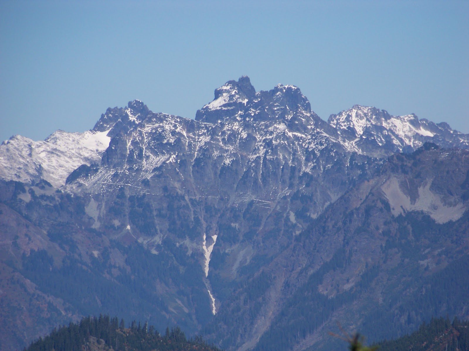
  I had a good night sleep and was up and eating breakfast semi early. I packed up and headed cross country to directly regain the Whitepine trail. The morning was perfect and the bugs were at bay. The only thing lacking were my legs. Although they were fine for the grade of the trail I started to wonder about the off trail climb to Upper Grace Lakes with a  heavy pack. The intent  was to drop pack around 7000' and tag Big Chiwaukum and then return to my belongings and traverse to Upper Grace Lake for my first camp. My plan for the next day was to go with a day pack over the pass and traverse to Opportunity Peak and then back and pack up and head up the steep snowfield to the summit of Snowgrass Peak. There is an umarked split in the trail in the first large meadowy area where the tread is equally worn. The trail descends and the route I had intended on taking rises. From this vantage I could see the snowfield I need to surmount Snowgrass and it looked very daunting. The truth of the matter is that I had decided to alter my plans and head to Frosty Pass directly. The views of the area are pretty inspiring.

After the junction most of the climbing has been done, it is a lot of ups and downs and parts are muddy and brushy. Thankfully with the big snowpack this year there is no shortage of water along the trail. I lost count of the numerous crossings. Shortly after the signed junction for the Grace Lakes Trail there is a horse camp where I stopped and shed some layers as the sun was heating things up quickly. From the camp I could see Frosty Pass and I was happy that it wasn't too much further. Shortly before the pass I met up with a solo on his way out. I chatted for a brief time before continuing my plod to the pass. Once cresting the pass I headed East on the Icicle Ridge trail towards Mary Lake. I passed a group of three who I surmise were doing a loop trip and had camped at Upper Florence. I had camped at Mary Lake many years ago and on that trip I had visited upper Florence Lake. I remember Upper Florence being by far the better lake but Mary provided better campsites.  Since Mary was closer it was an easy decision to camp there. I was thankful to have the place to my self. I used the biggest camp site that has it's own mini trout pond. The views of the Snowgrass-Ladies group was on display and the dog seemed at home


I lounged for the rest of the day and when the bugs grew too tiresome I did some exploring around the lake. I founded the one thing I desperately needed.... a snowfield.  No Ice NO problem


I spent the remainder of the evening reading and trying to put the traumatic events of last week into perspective while making my pack lighter by downing some bourbon. I made a great dinner and once the sun set I headed for less than restful night of sleep. Evidently my spot wasn't quite as level as I had hoped and I ended sliding off my pad most of the night. It did get surprisingly cold at night but I stayed warm in my bivy. Bosco was a natural and alerted me anytime any animals neared camp. The moon was only half but it did light up the night like a beacon. For those who haven't ever experienced a moon away from city lights and in altitude it something that words cannot ever describe. While I was off my intended schedule I could still make 7 of the remaining peaks. I eagerly packed a day pack and headed towards Upper Florence. The goal was Ladies Pass that is the shared saddle between Cape Horn and Ladies Peak which were my intended targets for this day. Mary's Pass went quickly and then I dropped some elevation before crossing Florence Pass. The basin that is between Florence and Ladies Pass is something to behold.  It is lush and green and immense why I didn't snap any picture I am not sure. Now I could see Cape Horn and it's North Ridge looked much more imposing than I had imagined


I plodded on towards Ladies Pass. I didn't realize that once cresting Ladies Pass the trail continues to climb. This enabled me to start the ridge much further up making the off trail portion much shorter. After a few switchback I spotted a worn track on the north end and followed. This led me to a small flat area on the ridge perfect for leaving my pack. I quickly made my way up the steep North ridge. There is plenty of loose rock but the footing is generally sound. Soon I found myself on the summit and wasn't able to find a register. I snapped a few pictures and quickly descended to my belongings.                                                               


  After descending to Ladies Pass I stopped and had lunch. Looking at the summit area of Ladies Peak I grew concerned. It didn't look inviting, I know it is doable with my capabilities but I started to wonder the wisdom of doing it solo. I decided to head up to see " how it goes". I made it up easily the first 400' and then I would have to traverse a ways before regaining the ridge. From there it looked doable until a couple hundred feet below the summit where I would have to do another steep traverse. I didn't like the look of it and decided it best left for another trip.


From the upper ridge I was able to Lake Bingham and I could see that it still had icebergs in it. I couldn't believe a lake at less than 6000' East of the crest could have ice still in it in Early September. I decided I should investigate. The drop to the Bingham is well graded and goes through some nice meadowy areas and I did have to cross a short steep section of snow that was still rock hard. I dropped 50' to around it instead of risking a slip. About a 200' above the lake I dropped to the immense snowfield on it South shore. I followed this down to the lake and had a short break. Bosco certainly enjoyed the snow. I was simply amazed at the depth of snow. I am certain that this will not melt this year.


I easily made my way back up the Ladies Pass. Without the weight of heavy overnight pack I felt like I was running up hill. When I reached the short steep snowfield I was very careful to kick good steps instead of going around it as I had done on the descent. Once back at the pass  I eagerly dropped to Upper Florence to do some fishing. When I was there many years ago I remember some VERY big trout. In fact one 20 incher rebuked everything I had to throw at him. He then had the gall to follow me around the entire lake taunting me as I went. I managed to land quite a few but none were lunkers. I did see some really nice ones but again they were very weary of what I was offering. After an hour I decided to head back to camp. On the descent I passed an older lady on a solo trip who hadn't decided where she was going to camp for the night. I find it inspiring to see people of all ages on the trail and I marvel at some of them. I do hope that when I reach my elder years I am still able to shoulder and overnight pack. Back at camp I made dinner and read before calling it a night. I switched spots to a more flat area that provided a much more comfortable sleep. The deer were out on this night and Bosco ran numerous deer out of camp at night. It is funny even though my sleep was disrupted it provided me much comfort and better sleep when he wasn't barking knowing that he was watching out for me. I again had to rearrange my plans when at Bingham where I could see the traverse to Snowgrass summit was still solid snow. This gave me pause since I was unsure how Bosco would do on a steep snow traverse. I had brought crampons and a ice axe so I felt like I would be ok.  Since prior to going to bed I noticed Bosco's limp more pronounced I decided that I was pushing him too hard. I had planned on heading to Doelle lakes for my last night but when his limp was even worse in the morning I decided to head out a day earlier. I settled for tagging Frosty Mountain before the long trudge to the car. I packed up and made my way to Frosty Pass where I dropped pack. I followed the trail to the horse camp a short ways before leaving the trail. I headed up and then hit a small ramp that had a fairly worn boot track heading up. I followed this all the way to the summit which provides a nice seat. I signed the register that was placed by Fay Pullen in 02' and had very few entries which didn't make sense to have a relatively worn path to it's summit. I had a short break and had to laugh when I caught Bosco lying on steep snowfield. I had to hold my breath hoping he wouldn't slide off of it.                                                            


I headed down to regain my belongings and head home. The heat was growing as I made my way out. It seemed as every step I took the temps went up. I was very thankful that again there was plenty of running water for both myself and the dog. I tried to stop for a short rest at a great spot about half way out and was marauded by black flies. I felt like if I stayed another minute I might not make it out alive. It took me about a quarter mile at top speed to finally loose the swarm. It certainly wasn't the rest spot I had hoped for. Not taking any chances I didn't stop the rest of the way. Finally after an eternity I made it back to the trailhead. Overall the trip served it's main purpose of allowing me to clear my head and did provide me a couple more summits. I hope to return to the area to finish my business. It certainly it a beautiful area and has now provided me two very memorable trips.


Popular Posts

lijit stats