Tuesday, October 25, 2011

Devil's Head 6660' and Bean Peak 6743' 10.25.11

With another stellar weather day on tap I was hoping to get out. I was puzzling over what to do when I got a text from Rob wanting to do something with some scrambling and moderate distance and vertical. I had been wanting to get out and do Devil's Head and this fit our time frame for this day. I picked up Rob at the Issy PNR and we were off and it was still very dark. I knew this would give us plenty of time. The road to the Beverley Turnpike trailhead was thankfully in much better shape than my last time. We suited up under some very cold temps. I would guess it was in the Mid 20's. The sun was just starting to warm the slopes above us and I really wanted to get into the sun since my hands were freezing. This became a constant theme for the day. On the sunny side of ridges it was very comfortable and very cold on the shady sides. We made quick work to the 4th creek Pass and dropped into the very frozen basin below us. After a short drop we were back to climbing to the pass between Bean and Volcanic Neck. We made quick work of this section and I led us on a traverse on the Eastern side of the ridge to avoid the cliffy areas of Volcanic Neck. I was able to find a small slot to cross the East ridge of the neck without having to drop some elevation to go around. The terrain on the North side of the neck was more benign. While I was doing this Rob tried to tease a route up the East face and was met with some resistance.


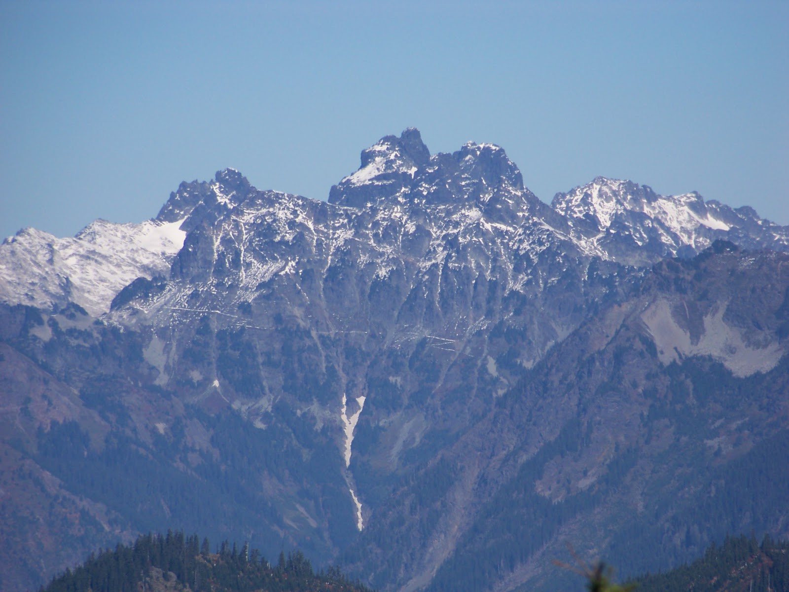
   We regrouped and headed along the ridge on fun terrain to reach Devil's Head which I thought was a brilliant time for a summit since this would be my last trip before Halloween. We easily reached the summit and snapped a ton of pictures since the weather was ideal as was the scenery. I had a good perspective on Sherpa and it's balanced rock. I tried to get a good picture to determine which is higher, From every perspective I have seen the balanced rock seems to be taller, but what do I know.


After a quick snack we headed back towards Volcanic Neck. I hadn't really planned to muster an attempt. Part of me wanted to save it for another trip since it was my last peak on the Teanaway Twenty that I hadn't climbed, part of me was enthused on the 3rd class scramble on potentially icy rock. I knew Rob wanted to try so I waited with the dog below. He called down to me letting me know that the route was gravy and repeated this enough times that I made my way up as well. After 200' of climb I was worried about the dog who hasn't had enough reps on this type of climb to make me comfortable to continue. I gave some thought to leashing him to a tree below and making another attempt but I was sure he would duck his collar and felt like this could cause problems. Soon Rob returned from a successful summit. We continued heading South to Bean which I had already climbed but I knew this would be a faster way out. I love the Bean Creek basin and I was looking forward to return anyway. We easily made the summit and there was a group of three already there. An older couple and their son. I was happy to see once again some older climbers making me hopeful for a long career myself. The group on the summit was heading down our ascent route so we parted ways. I headed East for a short ways before dropping. I wasn't crazy about descending a route that I hadn't seen before but I knew it wasn't very long before the mellow slopes would be reached. The descent is slabby in parts but the rock is very grippy making for an enjoyable descent. Once reaching the basin we had lunch and basked in the sun. The route out was easy and it had the added bonus of heading directly into the warm sun for long stretches. I try to savour each sunny day this time of year since I know it might be months before I see the sun again.

Approx 9 miles 3600' of climb 6:30 car to car

Tuesday, October 18, 2011

Meadow Mt. the circle route 10.18.11

Well you probably know the drill by now, worked late, had to be back early and needed something shorter. This version was augmented with a perfect fall day. I hadn't been in the area and my lack of knowledge provided a challenge that resulted in a much longer driving day than was needed. For those of you less challenged if you go towards Stampede Pass and take the spur that leads to Lost Lake you will be well on your way. If you would like to make it even less challenging you can turn just past Meadow Creek. At any rate after my joy ride through the maze of logging roads I found a spot that I could turn around and park, so that I did. I couldn't make the terrain and my map agree with each other so I wasn't quite sure I was where I wanted to be. I decided to head up in the recently planted trees aiming for a patch of more mature timber. The new growth was a pain but tolerable, once reaching the older trees the ascent became much more enjoyable. Soon I found myself on the ridge line and quite of ways from Meadow Mt. I headed North and came out on a logging road that was heading in the direction that I wanted to go, so I followed. Thankfully this road was slightly on the Northern side and was warm and pleasant. When the road tended on the Southern side where the wind was howling. I had to put my windbreaker and hood on to stay warm. It was quite amazing the difference 50' can make. I followed this road until it end where I surprisingly ran across a work crew just leaving. I don't know who was more surprised to see who. I left this road aiming again for a stand of more mature trees. I picked up a descent tread that spit me out onto another logging road which I again followed. When the road crested I left it for a nice rockslide going my way. I ran into my trail again that followed to just short ways away from the summit.  The views of Ranier from the summit are splendid but the lighting was poor so I wasn't able to capture it very well..


The views to the North where even better. The perspective of the Lemah-Chimney Rock group was from an angle that I hadn't seen before.


After a short stay on the summit soaking up the sun I made my way down. I used the trail that for more of the descent and replaced the nice rockslide of my ascent with a young tree jungle. The trees where so close together I had a tough time squeezing through. I managed to hit my logging road and followed it back to the car. It was very nice to get out with such a glorious day.


Wednesday, October 12, 2011

Blowout Mt. 10.10.11


With life returning to normality, for me anyway, I wanted to get out. The weather didn't look promising and I had to be back early so something short was in order. I have enjoyed my exploring of the South side of I-90 so I thought I would try to shamelessly bag another scrub peak. I thought Blowout Mt. would be a good fit and since it was well over 5000'  I hoped to lay some tracks ins some fresh snow. I was able to keep myself on route all the way to my jump off point. I used the road that goes to Stampede Pass and then took #41 East until I reached Log Creek where I continued on this road that hopscotches over Log  Creek numerous times on bridges of suspect quality. There are many bumps that channel water away from the road that one needs to go over so some clearance is required. The Subaru managed most of them without too much damage to the under carriage. Finally I reached one bump that I wasn't sure I could make it over so I parked. 

   Even though the skies were spitting snow I stayed in shorts and just layered up with some extra shirts and a raincoat. I walked the road until I reached the trail I had hoped to find. The trail sees heavy motorcycle traffic but it seems like someone has taken the time to add some traction on some of the steeper portions to keep some of the tire erosion down. Once cresting the ridge the snow markedly increased as did the snow showers.


I easily followed the trail towards my intended target. I quickly had lunch and retraced my steps in the growing showers. By the time I got back to the car the weather was vastly improved but I still had very stunted views. While the hike didn't provide much in the way of exercise it did provide once again some vital time for me to put things in perspective.

Wednesday, October 5, 2011

Snaggle Tree Peak 4898' 678P' 10.5.11


With the lousy weather I was unable to coax anyone in going out with me. I instead decided to have a family day but after running some errands and with us watching an additional kid I somehow found the motivation to get out. I didn't have very much time so I thought I would indulge myself in some shameless peakbagging. After consulting my maps I found Snaggle Tree Peak would fit my time frame. I made my way to Stampede Pass before turning onto #41. I was thankful that all the many people on the roads let me by since I had a schedule to keep. I am still not sure why there were so many people out, maybe scouting for hunting? I didn't see anyone actually outside their rigs, which I am sure had something to do with the crappy weather. After a few miles on #41 I hung a right and headed South. I was intending on just parking and getting a few miles in but the road was in good shape and there wasn't any good places to turn around. Soon I found myself at the end of the road. Thankfully the terrain matched my map and I was reasonably sure I was were I wanted to be.

   I quickly changed in the driving sleet. I was expecting the chance for some snow and I think another few feet of elevation I think I would have had my wish. I headed off on a rather brush less track and then dived headlong into the very wet stunted trees. I aimed for some standing timber finding easier going. I crested the closed contour and then descended to a saddle and then popped out on some good tread. I followed the trail to the West for a short ways before diving into the brush. I found an old road that headed to the treed summit. I am guessing the peak is named for the two bleached snags at the summit. I criss crossed the area before deciding the highest point was the root ball of a fallen tree. Since the views were non existent I didn't linger long before retracing my steps. I was a bit concerned for my way back since I had no line of sight and everything looked the same. I quickly made it back to the closed contour and then tried a slightly different route back trying to avoid the worst of the dense new growth. I came out on a trail and I was sure I had traversed too far, so I back tracked. I ploughed back into the brush finally coming out on a good trail. Realizing I was just under the summit I just had climbed I retraced my steps and made sure to head out the same way I had come in. So much for saving some time in the brush.


Miles, Not enough, elevation, not nearly enough 1 hour car to car

Popular Posts

lijit stats