Tuesday, February 11, 2014

Ski Acres Hill 4200' 2.11.14


Since the pup has had an injured leg for some time and everything I have tried to get him to stop licking it has failed, it was time for drastic measures. Thankfully after a short period of the dog freaking out he has settled into his new collar.  I decide also to give him a couple of weeks off of hiking to make sure it heals properly.
As it turns out I doubt he would have been able to do very well in the very deep snow.


I had read a report from John Morrow of  a ski tour he did last week and it piqued my interest. A hearty thanks for John for giving me lots of additional beta for my attempt. I was pleasantly surprised when I awoke to find it not only not raining but rather warm with some hazy sunshine. It was well above freezing at Snoqualmie Pass. I am not too familiar with the area but with John's help I was able to find a suitable jump off point. I parked at the new lodge next to the Silver Fir lift. The were only a few cars when I arrived. I suited up and soon connected with a old snowshoe trench right off the bat. It was covered with a good 18 inches of snow but I was able to follow it to connect with the crossover road where I went left thankfully crossing Hyak Creek on  a bridge. I thought I had seen some posts of groups having to cross the creek without one. If I remember it correctly it didn't look too enjoyable. I followed the crossover road a short ways past the creek crossing. The pup is currently recouping from an injured leg so I thankfully didn't have to worry about him running amok. I was careful to stay in the outside edge of the road to minimize the damage to anyone wanting to ski the road. Once leaving the road I quickly found another trench heading my way. It stayed quite near the creek and made for easier walking. I don't think I would have nearly as much enjoyment on this day if I hadn't been fortunate in my route finding.  Once I reached the power line corridor I was faced with continuing on with the trail or heading up the corridor on another trench. I could see what looked like some easier going higher up the power lines. It almost appeared like an avalanche had come down but because the there wasn't much slope I surmised it was  caused by something else. Once reaching this area the pace quickened. It appear the area was packed by a snow cat and was provided some quite solid footing.


The plowed area started heading away from where I wanted to go so I made my way up in the deep unbroken snow. The going was quite slow but I was determined. I broke out on one of the groomed runs which was a little steeper. I again walked to the far outside of the road but I am not sure it mattered since I could barely see my tracks anyway. I followed this for a ways until it again started heading away from where I wanted to go. I followed what looked like another road but this was unbroken. It seemed like there may have been some sort of trench since I was able to find easier going in the middle of the road.  I decided that the pitch wasn't enough to get me where I wanted to go so I left the road. I went through some very deep snow that forced me to meander through some new growth trees with plenty of tree wells to slow my pace even more. I decided to turn around and regain the road since I was making much quicker progress. To make matters even more difficult the decking on my snowshoes broke on both making it feel like I was walking with shoes where the sole had separated from the shoe. I could have used more float and this certainly didn't help. I decided that I was going to have to pare down my aspirations. I had hoped to continue on the Ollalie Hill. I found some older growth trees with better snow conditions putting me right under Ski Acres Hill. Once the pitch increased again my pace slowed. I decided to give my self a better chance so I dropped pack here and wallowed up the steep portions. Thankfully the steeper portions were short and I was able to reach the summit. There wasn't much to see so as usual I didn't linger long. I gave some thought to mixing up the descent but since my gear was stowed in the wrong direction I decided to just retrace my steps. Overall the short trip was made more difficult with the snow conditions but I felt like I patched a route together which wasn't the most direct but substantially easier.

Approx 4 miles 1400' of climb 3:30 car to car


Tuesday, January 28, 2014

Middle Muffin 4015' Big Muffin 4600+ Little Muffin 4280'


Headed up the Meadow Creek Valley near Snoqualmie for an enjoyable day out. I managed to get out of the house at a decent hour and was greeted at Snoqualmie Pass with freezing rain. I had hoped that the road was open past the Crystal Springs Sno Park but I found the road bermed with snow. I drove through the Sno Park parking lot and found the connecting road driveable. The main line was heavily packed and made for easy driving. I was excited because I had done this same approach 2 weeks ago but on that trip I was forced to walk the 6 miles to my jump off point. I was able easily drive the entire way to the spur road that I needed. I parked off the side making sure I was going to be able to get out for the drive home.


Thankfully the rain had ended as I suited up. I walked the packed road for a while before I reached a junction heading my way. I saw some boot prints in the snow which surprised me..... well until I realized they were my prints from 2 weeks ago. It gave me a good chuckle anyway. Once I reached a junction where I had headed right on my last trip, I instead headed straight into the trees. The snow was pretty icy and firm. Initially I felt good without traction aid. As I climbed higher I switched to crampons. The last 100 feet before the ridge was steep and icy and debated getting out my ice axe. I instead made doubly sure of each step by kicking at least 3 times to break through the healthy crust. Once reaching the ridges I made a short ways to top out on 4015', while it only has around 150' of prominence I thought Middle Muffin would be a good name. I descended the ridge to intersect the road below me. This line was much more direct than taking the mainline road that heads to the summit of Big Muffin. I followed the road until it's end where a snowmobile had continued heading towards the summit. I stayed in the track and soon found myself on another road which I crossed and headed off trail for a short ways to reach Big Muffin 4600+. Views were non existent so I didn't linger long.


On the descent I stayed on the road the entire way avoiding the steeper off trail of my ascent. When I reached the spot the main intersection I was happy to see that it was still early. I decided to continue on another packed road heading to Little Muffin. In short order I was able to climb on the road until I was just below the summit and I wandered on some low angle terrain until I stumbled across the summit of Little Muffin 4280'. Again I didn't waste much time on the summit and quickly headed back to the car.


In the short time I was gone the weather warmed considerably making it difficult to get the Audi back onto the mainline.  I soon realized that I wasn't going to get the car out without breaking out the snow shovel. Thankfully I have packed the car to handle just about anything. After a few tries I thankfully was able to back the car back onto firmer snow and regain the route home.  The drive out was uneventful until I reached the freeway and my car was shaking like mad. I had feared I had bent my wheel while I was stuck so I pulled over to check out the problem. Thankfully the problem was just an immense amount of snow packed into my wheels on the passenger side making them roll completely odd. I did my best to get out the snow and gave it another go. Still shaking I pulled over again and found a stick to get the snow out I couldn't quite reach. Thankfully it was just the ticket to get the car back to normal. Another nice day to get out.

Approx 7.7 miles 2400' of climb 4 hours car to car

Wednesday, January 22, 2014

Howson Creek 1.21.14


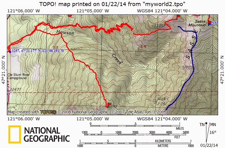
I had aspirations of climbing Howson Peak but I couldn't decide how I wanted to attack it. I had tried once before using the old Howson Creek Trail until just before the creek crossing. On that trip I left the trail and headed to the SE to 5159'. On that trip I found fairly easy travel but ran out of gas after making it to 5159'. I also had climbed Not So Sasse Peak via the Howson Creek trail. I decided on the drive over to Salmon La Sac that if the snow cover was low enough I would use the more direct route of going over 5159 and if there wasn't any snow down low I would stick to the trail.


I was surprised on cresting Snoqualmie the weather was in the mid 20's and there was much more cloud cover than the West side of the pass. I had hoped to spend the day in the sun.  I had some trouble finding my jump off point despite being there a few time. It seems between the growing number of trips I have done and my fading memory I will need to do more homework before heading out. The trail is no longer signed and is quite a bit before the crossing of Howson Creek. There is a allowed parking on the West side of the road directly across from the start of the trail. The trail starts as a old road bed until it reaches the crossing of Howson Creek. There was very little snow so I decided to stay on the trail. The creek crossing was a bit sketchy because all the rock above the water line were caked in ice. I chose to walk in the creek to cross which wasn't deep enough to cause any issues. The snow was just soft enough to get enough traction without any aid. The trail was easy to follow since it was for the most part the only snow. It was like following a ribbon of white. At around 3800' the sun started peaking through and I switched to crampons since the snow was becoming less friendly. There were still long patches of bare dirt which for Mid January at over 4000' was quite disturbing to me. I was able to follow the trail until 4200' where I lost it. I couldn't remember much of my previous trip, I did remember that the trail turns the corner and starts traversing towards Sasse Mountain but I couldn't remember at what elevation that occurred. I just kept heading up finding a manageable grade and good snow conditions. What wasn't in good condition however was my fitness level. Even with great conditions I was making very slow time and it was very apparent that there was no way I was going to get anywhere close to my goal for the day with the time I had available. I also realized that I wouldn't even have time to make it to Sasse Mountain as a back up. After some debate I decided to retreat in order to make in home in time for my evening plans.


This trip highlighted some areas I need to better focus on. More homework before leaving the house and while I have been doing quite a few miles per week it doesn't substitute as well as I had hoped for actual climbing. As I have noted before there is an appalling shortage of snow at the moment. Looking at the extended forecast I don't see that changing any time soon.


Approx 5 miles 2300' of climb 4 hours car to car

Wednesday, January 15, 2014

Meadow Creek Wanderings 1.14.14


I had hoped to climb Big Muffin via Meadow Creek but the road has been closed past Crystal Springs Sno Park since last week when I was there. I had thought this might be an issue so I had been prepared to walk the 7+ miles of road to the summit. I gave some thought to another objective but in the end I really just wanted to get out and the result was much less important. Since I didn't have a Sno Park Pass I parked at the newly placed snow berm blocking access to the road to Stampede Pass. There isn't much snow on the road and I wouldn't be surprised if it is all gone by next week. I headed on the Lost Creek Road for about 2 miles until I reached the Meadow Creek Road. The snow became deeper but was well packed by the snowmobile traffic. At around the 5 mile mark I hit a junction heading my way and found slower going with the lessened traffic. I resisted putting on snowshoes even though I could have made a case to do so. Once reaching a painfully flat section of the road I left the road heading up. The snow was about 2 feet deep on a solid base. I again reached my road cutting the switchback and headed a short ways further until reaching an area with some nice territorial views. The weather was partly sunny and well above freezing so I enjoyed my lunch. I still had nearly 2 miles to go in deepening snow so I contemplated my options. I would surely be coming out in the dark if I were to continue and I would also miss dinner with the family. In the end the lure of spending time with my family won out and I headed back. The last 2 miles seemed endless and I was very happy to reach the car.

Approx 13 miles 1600' of climb 6 hours car to car.

Popular Posts

lijit stats